Monday, May 7, 2012

Sequoia trees and why photographers hate them

Try to photograph a Giant Sequoia. Can't do it unless you have some fancy lens. I have seen people lie on the ground pointing their camera upward and they still can't get it all in. So I get a shot of the base, 1/3 up and then the top. I am so glad I saw the Stagg Tree all by myself and that I drove that crazy highway to see the Trial of 100 Giants because they don't limit access to the trees but when I moved my camp up to King's Canyon the trees are all fenced. At one point they were naming trees after states but stopped.
The Tennessee Tree had a fire raging inside it, so the park service climbed a Jack Pine that was close to the big sequoia and then transferred over to the sequoia and hauled up a fire hose and pumped water down into the tree to stop it from smoldering for days and possibly killing the tree.
The bark on these things can be over 2 ft thick and have tannin in the bark. They need ground fires to help clear the ground cover because they like a very sparse understory. Fire helps open the pine cones also.
These trees are very stingy with their pine cones. The cones are only the size of a plum but longer and narrower. The tree will sometimes keep the cones on the tree for 20-30 YEARS before it lets them drop. But I guess if you are a 3000 year old tree, you are entitled to drop your cones, any damn time you want!
On the sign for one of the 2 largest, I frankly can't remember which, it said that in order to get an idea about the volume of  wood in these trees, picture taking a bath every day of the year for 27 years and that is how much water/volume the tree can hold. In the late 1800's, two men took 9 days to cut one down and send it to some celebration in Washington. They only sent the shell in pieces and put it together at the event. No one believed that such a thing could exist in nature.
Sequoia and Kings Canyon have been really serious about bears. Apparently the bears have figured out what a cooler is and what it looks like and what it contains. So you can't keep any food in the car. They provide these fancy, difficult to open steel boxes for all food, coolers and waste. They advise to not get more than an arms distance from your food at all times. You are supposed to protect your food and scare the bear away with rocks and things (but don't hit it in the head) because they don't want the bears to learn that they can scare humans away from their food. In the back country they say hanging your food in a bear bag doesn't work because they will climb the tree. They are selling steel cylinders to pack all food in when back packing. So I haven't seen a bear here but you better believe that if a bear approaches my food, I will let him have it. The problem is I can go into my car, but the bears have learned how to break into cars. The last time I actually saw a bear was in NJ at Swartswood State Park but they weren't as aggressive as the bears out here.
I left Kings Canyon and found a KOA Kampground in a town called Coarsegold, CA. It is on the access road to Yosemite. Sequoia grow up at 6-7000 ft and it was too freaking cold after dusk. I have the clothes for cold and the sleeping gear for cold but it is impossible to sit in front of a campfire and read when it is so cold. I have seen enough Sequoias so I came down to 1500 ft and am enjoying hot showers and wifi in coffee shops etc. Getting the next roll of film printed and put on disk. Will mail another package home. I have been collecting pine cones. The Sugar pine has a cone about a foot long and I got myself one!
I am having a perpetual spring. The red bud were blooming in W VA the first week of my trip and a few days ago I drove into Kings Canyon and they were just blooming there. The good part of perpetual spring is that I get to see a huge variety of spring blooming wild flowers.
I have qualified for tthe Grand Prix of driving after doing the mountain roads heading into Sequia, going over the pass to the Trail of 100 Giants, going into Kings Canyon Park and then down into Kings Canyon itself. These are all windy, switchback roads with suggessted 10 mph on turns. Have to keep on your own side and watch, watch, watch

Thursday, May 3, 2012

Valley of Fire State Park, colors

Me at sunrise, Bryce. It was cold.

Me at the beginning of "The Narrows," a 17 mile slot canyon at Zion

On  my climb out of Bryce amphitheatre

Sunrise at Bryce

early sunrise lighting up the hoo doos

Valley of Fire State Park, colors

View from my tent at Zion

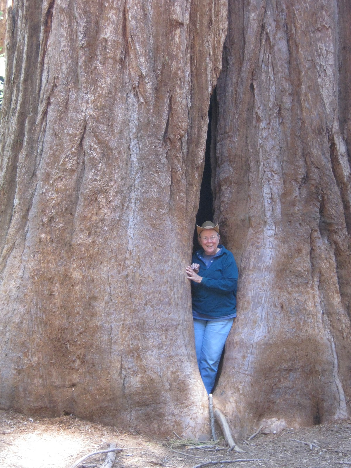
Me peaking out of the base of a Giant Sequoia at the Trail of 100 Giants.

I hiked in to find this tree called the Stagg Tree. 3000 years old. The base of Sequoias can stand ground fire because they have tanin in their bark. Fire is good to clear the understory for their seeds to flourish. Small pinecone for a huge tree.

This is a modest size Giant Sequia but you can get a feeling for how large they are with my car as a reference

Monday, April 30, 2012

Rodeo and 3000 yr old sequoia

I feel like I haven't written for a long time but it is only a matter of days, but I am seeing so much. From Vegas I took the back roads instead of I-15 down to Desert Hot Springs. What a ride across the Mojave. Lonely and only two lane but no traffic and big rigs to deal with. Saw borax deposits and they actually were driven out by 20 mule teams, also saw a lava cone.

Desert Hot Springs was amazing because it is backed up by Joshua Tree national Park and across the valley is San Jacinto Mt at over 11,000 ft. It is a large valley with thousands of wind turbines. They are working on their 5th generation of wind power and the generators are everywhere dotting  the hill sides. Huge wind goes thru the Palm Springs area . Went over the pass on the way to the outskirts of LA. I went to Sequoia National Monument and the roads were all 4-5 lanes most of the way. The smog was very noticeable.

Went over a pass and ended up in the Central Valley of California. Breadbasket of the state. Massive valley with farms everywhere; citrus, nuts, veggies you name it, over 240 crops as well as dairy and beef cattle.

On my way up to my campground my last town was Springville and they were having a rodeo. so I went to the rodeo on Sunday. The first rider out of the shoot, bareback bucking bronco was absolutely mauled. I was horrified but they just dragged the guy out and continued. No stretcher or anything.

Today I drove up 4000 ft to see the third largest Sequoia tree called the Stagg Tree. 95 ft around. Awe inspiring. The pass up 190 that leads to another grove of Sequoias is finally open, so I will attempt that another day. I was hiking through some snow today looking for the tree. Took my hand held GPs in case I got lost. No cell phone service up this way but they do have this satellite 760 k wireless at a cafe I found up at 5000 ft  in a place called Pierpont Springs. Chain country in the winter. It is so amazing to be up at such elevations and have huge forests. In NH White Mts I would have been close to tree line at 4000 ft.

So I am officially in the Sierra Nevadas and Mt Whitney at 14,000 ft is the highest mt in the lower 48 is in this range. I am camping next to a rushing torrent of the Tulare river and it is is in a grove of huge mossy covered trees. I could barely find a space big enough for my tent. My hot water heater is pumping water but not producing hot water and I am hoping it is just a temporary thing. The temps are warm enough to take a cold  shower but............ The families with kids all left after the weekend and I have the place to myself and the Camp Host and just a few others. Slept till 11 AM today! I better close and leave for  camp as I talked to the host and told him where I was going so I need to get back before dark.

I went the farthest west I am going on Saturday at about 4200 miles so far. Having the time of my life and wish you were all here so I could tell you what it is like in person.

Wednesday, April 25, 2012

Amusements at the Stratosphere

There are four. 1) " Scream Therapy" @ 1149 ft. hoisted up the outside of what looks like a radio tower and let to free fall 2) "The Insanity" @ 983 ft spins out from the side of the building 3) "The Scream"@ 866 ft a module holding 4 sets of people rocks back and forth over the edge of the tower and dips down and up etc. 4) "Sky Jump" at 108th floor. At this level the glass slopes outward so if you sit on the floor and hold onto the edge you can lean out and watch the whole thing happening. A person is put in a light blue and yellow jump suit and harnessed at the torso. They are attached to a bungee cord type thing and guy wires. The person is launched off the platform and freefalls in a controlled fall to a target circle painted on the roof of the entrance. You can buy one ride or get bargains for up to all 4 rides plus if you aren't a resident of the Stratosphere is another fee. The individual rides start at $13 and another $25 to get in the building if not a resident. Pictures get taken of the participants during the "fun" and can be purchased at the exit desk.
I really decided that mortgaging my house for last night's dinner precluded me from partaking of any of these sports. But if any of you want to do them I thought I would provide the info for your next trip to Las Vegas.

From 30-114 degrees - The Bryce Adventure

The Guide Book says see Bryce Canyon National Park at sunrise. It is 86 miles from Zion to Bryce and then a few more miles to actually get down to Bryce Point where the book says is the best place to watch said sunrise. I set my alarm for 4:30 AM, hopped into my clothes and headed for Bryce. I had prepacked everything I needed the night before. It would happen, of course that I have slept like a log every single night of the trip with the exception of  this one night! The first part of the trip was up the twisting, hairpin turn route 9 on which I came into the Zion valley. Could not make time on that stretch. The sky was horizon to horizon with stars but I knew I was trying to beat the sunrise so I really put the petal to the metal on route 89 north. I arrived with 10 mins to spare. As I drove up the plateau toward Bryce the temperature kept dropping and it was 30 degrees at one point. I hadn't thought of that but did have a fleece and my cowboy had in the car as well as a poly pro top in my pack. So on Sunday, Earth Day, a group of us gathered at Bryce Point and watched the sun come up over the 10,000 ft peaks in the distance. I have to say I was not impressed with what the sunrise did to the rocks. They were impressive enough but I didn't see any great affect from the sun hitting the formations at a low angle. The HooDoo's, as they are called are amazing to look at and the color changes in the rock layers was interesting.
I ate breakfast and at 8 AM headed down the Navajo Loop trail to enter the Bryce "Amphitheatre." I was somewhat apprehensive about hiking down into the canyon because I couldn't get any real accurate figures about the elevation involved or distance. The rim was around 8000 ft to start with. But I headed down anyway and found the trail a mastery of trail work. At one point the trail went down this narrow canyon with 14 switchbacks to get down through a steep section. Then it evened out more and I met up with the Queens Garden trail and headed back up to the rim. The days had been very hot and I wanted to get down and out as fast as possible. The way out wasn't as steep so it was an enjoyable hike and I was really proud of myself handling the elevation. I topped out around 10:30. It was worth going into the canyon to see it all from below as well as from the rim. I then headed back to Zion. I got very sleepy driving and had to stop and get some coffee and food before I could continue. It was great to see the plateau that I had sped across during the night and it was fascinating to see the Seviere River follow the road a good distance. Then I got to drive route 9 again in daylight and it was as good as the first time I drove into Zion.
I have been experimenting with how I leave my tent flaps during the day. Up to keep the sun out, but the breeze out or down to let the breeze in, if there is a breeze, but pretty open to the public. I had left the flaps up and when I got back the tent was in the high 90's. I opened it up but was so sleepy I lay down in the heat for an hour or two. I think I fried my brain because when I woke up it was 114 degrees in the tent. I staggered out and sat in my folding chair in the shade of my tent and drank everything in sight but I really didn't feel well and never ate any dinner.
It had been a very long hot day the day before so the next day I did nothing but sit in a rocker on the covered veranda up at the Zion Lodge and pretended I belonged there. Never broke a sweat all day. Good way to recover.
Off to Las Vegas via the Valley of Fire State Park. I had been hearing about the place from others and it had little green dots on the map and was in my Scenic Byways book so I made it a must see. But then the section of road south of there to Las Vegas was nothing but desolate desert and it spooked me out. Nada, nothing, nobody but me! After 40 some miles there was a break in the mountains and I got a glimpse of Las Vegas and the Stratosphere tower. What a reliainef to see civilization again.
My son had recommended a certain steak house in Vegas called the Golden Steer, which turns out to be within walking distance of the Stratosphere. He always went there on business. I will now have to take out a mortgage on my house to pay for the meal.
Today was Hoover Dam and then the Scenic Byway through Red Rock Canyon. I really don't need to see any more red rocks. Hoover was interesting but so grand I didn't even bother to take my camera. The tourist facilities were very well done and fine materials were used including marble for the flooring and polished railings.
There apparently is an amusement park up on the top of the Stratosphere Tower and on my drive back this afternoon I could see one of those things where you sit in a swing and it swirls around, the swings fly out and around you go. Only the people in this one were being swirled out over nothing. I may go up and check it out now.
Tomorrow I am off through the Mojave Desert to Desert Hot Springs. At least I will be on a well traveled interstate 15 so I don't freak out.

Saturday, April 21, 2012

Roads with little green dots

What can I say? I had no idea what I was in for at Zion and when I first started to get into the area I thought I must be in Yosemite, but I knew what I was seeing wasn't formed by a glacier. The ride to Zion over route 9 is one of those rides that AAA puts little green dots next to. Always follow the roads with green dots if you want to have a wicked good experieince. Massive uplifts of mountains and peaks all of differnent color and strata. The Zion Canyon is formed by the Virgin River. The river is only 160  miles long and drops over 50 ft per mile. It really packs a punch as far as eroding the valley and slot canyons in the area. The main part of the valley is serviced by propane propelled shuttles eliminating all the car and noise of RV's, and buses. There are stops all along the valley that coincide with interesting features or trail heads. I took it up to the end to the Temple of Sinawawa and worked my way down the valley stopping to hike at 4 places. The valley continues farther north and is called "The Narrows". It turns into a slot canyon that follows the river, often only 20-30 ft wide but 2000ft deep. I learned to rock climb with the idea to do some techinical slot canyons in Utah but never got out of the NE for climbing. this is a major world class rock climbing area and you have to be uber into your self confidence and capabilities to attempt these routes uup the massive walls. all day we watched a pair making their way up a crack.

Tomorrow is the day I will be going to Bryce Canyon. It is 200 miles roundtrip so I don't know if I will get to hike down in the amphitheatre. The geologic strata is so interesting and goes from north to south. This whole area was one big lake at one point (think million of years) and the different strata were laid down and then fused into rock. Then they were uplifted at crazy angles and then eroded. So the bottom strata at Bryce continues south and is the top strata at Zion. And the bottom strata at Zion is the top strata at the Grand Canyon. The Vermillion cliffs that I passed on the way up here are all part of the same uplifting and erosion.

Temps in Zion are wonderful. 50-60's during the night and 80-90's during the day. I will never complain about heat after the cold I have been through.
Getting good at making my own percolator coffee. I added filters and it helps to keep the grounds where they belong. Cooking has not been all that great and last night I really fell to an all time low. I made "Tuna Wiggle." The first "one pot" meal that Girl Scouts learn to make. And I made enough for three meals. yuk. I put a lot of effort into my itinerary and not anything into recipes for one pot or two. Used the shower accessory to my hot water heater for the first time yesterday. First day I have wanted to take a shower  that wasn't indoors!

Can anyone tell me how orchards can grow right at the edge of really dry places? I am seeing a lot of orchards in the strangest places.

Today is day 21 and I have put 3100 miles on my car.

Wednesday, April 18, 2012

Tumblin Tumble Weed

Yesterday was a drive from Navajo Lake State Park all the way to Page, AZ. A WOW moment all day. I was supposed to stop at Navajo National Monument and did stop and took the walk out to see the cliff dwellings. They are similar to the one at Mesa Verde but  there are three separate ones at this site. They are located under huge cliff overhangs. This one went back 135 ft, had a spring and natural southern exposure. They grew crops down in the valleys where their cliff dwellings are located. I went on to Page. The scenery again was beyond belief. Ship Rock, a monolithic piece of Lava sticking up out of the high desert plateau was visible for miles off. After that the soils turned more like red sand and there were more sandstone outcroppings.
The road I was on was only 2 lane but there were hardly any cars and so I could do 65 easily. That is except when there were goats, sheep, beef cattle horses and yes, even a tumblin tumble weed crossing the highway. Very high desert but enough land for grazing. I was going down a huge valley with the the strata on either side perfectly horizontal and down the middle were a series of hogbacks which are uplifting of strata on almost a 45 degree angle.
I was getting 56 mpg on this tank of gas, going up and down through the desert with that 180 degree sky visible all around.
This campground in Page has a pool and Sauna and showers and I am currently sitting outside of my tent at my picnic table connected to the wifi. It is a lovely 76 degrees and a light wind and my tent is open to get the cross winds. My tent site is in a little 2 ft high walled enclosure in this immense land of class A diesel pushers and every other kind of RV you can think of. Gorgeous sleeping last night with just a liner and light quilt. What a treat to get up and dressed without freezing.
The big treat and something on my bucket list was visiting the Antelope Slot Canyon this morning. It is on Navajo land and can only be visited with a Navajo guide. I have seen pictures my whole life of slot canyons and how the light streams down and reveals all the twists and turns and erosion of millions and millions of years of an intermittent stream flow. The stream that carved this slot originates up over 6000ft and does this canyon at 4000ft. So If they see that there is a storm out about 25 miles they will evacuate the canyon and the dry arroyo that the trucks use to get us to the slot. I took so many pictures. No flash used as it blots out the colors. I am so psyched by seeing it all. But I have not found a book of photographs done by a professional. Would buy it in a minute and can't wait to see how my prints come out.
Page only started in 1957 when the Glen Canyon Dam was started. It took several years to build and then 17 years to fill Lake Powell. I drove over to a scenic point across from the dam and it is quite impressive. I did not take a tour as I want to do that at Hoover Dam. When we rafted the Colorado we left below the dam at a place called Lees Ferry.
Tomorrow I head to Zion via back roads again but I expect they will be WOW moments the whole way.